In this article, you’ll learn the basics of airspace classes.
This airspace study guide will help you prepare for your written test.
Airspace is a region of air that is available for flying aircraft. However, the precise nature of aircraft that can fly in these regions, and the circumstances under which they are permitted, will vary from one area to another.
As with land, the air above the ground is generally owned by private landowners, governments, and states. There are certain laws and restrictions that therefore must control the use of flying vehicles in these areas.
The first thing you need to know in this airspace guide is there are two general categories of airspace classes: controlled and uncontrolled.
Uncontrolled airspace is airspace that ATC does not control.
Controlled airspace is exactly that, airspace regulated by ATC. This includes Prohibited, Restricted, and the many different airspace classes.
Controlled Airspace Classifications
Whether training 141 or 61, one of the most important things you learn as a new pilot is airspace classes. You want to be transmitting and listening on the correct frequency at all times. Write down all applicable frequencies and have them readily available for your flight. It’s going to make you much less stressed, and can save you from an embarrassing transmission as well. Be sure to have extra pens or pencils on standby in your flight bag.
There are 6 primary classes of airspace we’ll cover in this guide.
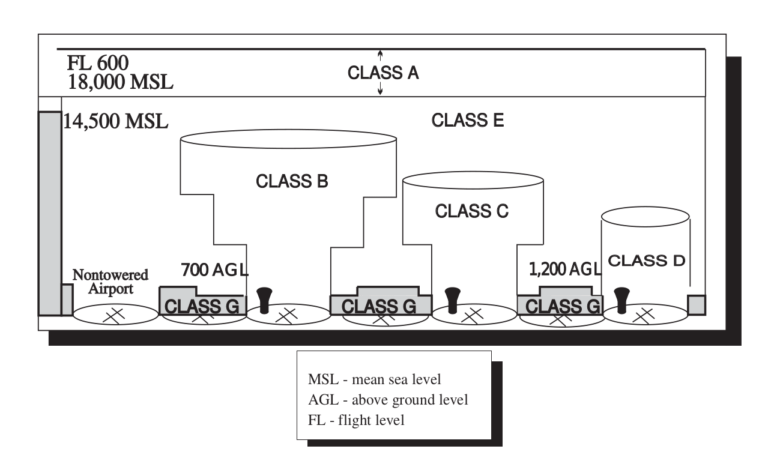
This airspace classification chart gives you a basic idea of all of the airspace classes you should know. What’s missing from this airspace diagram is the specific airspace altitudes associated with each class. We’ll cover each below.
Class A Airspace
Class A airspace is the airspace from 18,000 feet mean sea level (MSL), up to and including flight level 600. This includes the airspace within 12 nautical miles from the coast of the 48 contiguous states and Alaska.
Operation in class A airspace must be conducted under instrument flight rules (IFR), except in very specific circumstances.
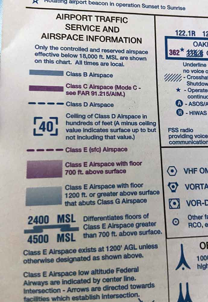
Class B Airspace
Class B airspace is the airspace between the ground level and 10,000 feet MSL around the country’s busiest airports. Here flight is extremely regulated in order to contend with the high amount of air traffic. Air traffic control clearance is required for all aircraft operating in the area. The configuration of each class bravo airspace is unique in that the area gets larger as your altitude increases.
Class C Airspace
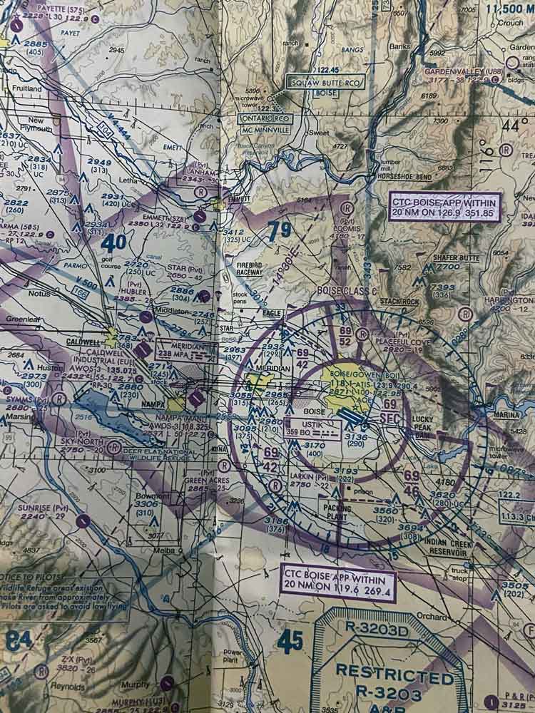
Class C is the airspace from the surface to 4,000 feet above airport elevation in the regions around airports with operational control towers and radar approach control. These are also airports which have a particular number of IFR operations/passenger enplanements.
Once again, the configurations of these airspaces are individually tailored to each area. That said, Class charlie airspace normally covers a five nautical mile radius around the airport that extends from the ground level to 1,200 feet and an outer radius of ten NM from 1,200 feet to 4,000 feet.
All aircraft in class C airspace are required to engage in radio communication with the air traffic control before entering the airspace and while they are within the airspace.
Class D Airspace
Class D airspace is between the surface and 2,500 feet above airport elevation at airports with operational control towers. Like others, Class delta airspace is configured individually to the airport.
IAPs (arrival extensions for instrument approach procedures) can be either Class D or Class E airspace.
As with Class C, aircraft must establish a two-way communication with ATC facilities that offer air traffic services prior to entering and once within the airspace.
Class E Airspace
The last of our airspace classes is Class E airspace. This is essentially a catch-all. It’s the controlled airspace that is not categorized as class A, B, C, or D. Most of the airspace located across the US is designated as Class E=echo airspace. The aim is to cover sufficient airspace to enable the safe control and separation of aircraft in IFR operations.
You can learn more about the different types of Class E airspace by referring to the Aeronautical Information Manual (AIM).
Most charts depict all areas of Class E airspace with bases under 14,500 feet MSL. Where this is not illustrated, the class E airspace is still assumed to begin at 14,500 feet MSL.
Class E airspace base is 1,200 feet AGL in most areas. However, it is also commonly at 700 feet or even at the surface.
Usually, this airspace class will extend up to 18,000 feet MSL (not inclusive). Anything above FL 600 is Class E airspace.
Not sure if you have all the gear you need for flight training? Take a look at our list of essential gear every pilot should carry in their flight bag.
Uncontrolled Airspace
Next let’s take a look at uncontrolled airspace classes.
Class G Airspace
Class G Airspace is the uncontrolled airspace classification. This means that the airspace is not included under class A, B, C, D, or E. It extends from the surface to the base of the overlying airspace.
ATC has no authority nor responsibility for air traffic control in these regions. However, pilots still need to adhere to the visual flight rules (VFR) minimums.
Special Use Airspace
Some airspace is restricted to certain activities or there are limitations on aircraft activities in the area. This is known as either special use airspace or special area of operation (SAO). In some of these areas there are restrictions placed on the mixed use of the airspace.
Special use airspace, also called special area of operation (SAO), is a classification for airspace where certain activities must be confined. In other cases, it may be an area where limitations can be imposed on aircraft operations that fall outside the remit of those activities. In some cases, these can create limitations on the mixed use of airspace.
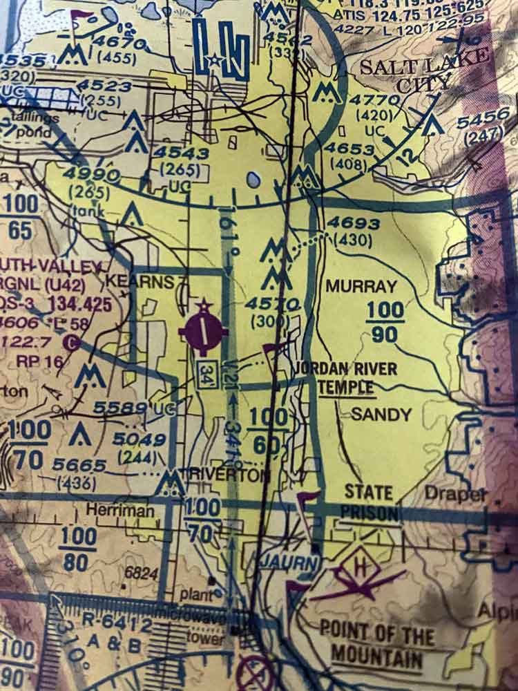
Special use airspaces are depicted on charts, and should also include the name, number, and effective altitude.
The most common forms of special use airspace include:
· Prohibited areas
· Restricted areas
· Military operation areas
· Controlled firing areas
· Warning areas
· Alert areas
For example, if a military exercise should be carried out in a particular airspace, then it is important for rules and limitations to be imposed on commercial airlines passing through. This can help to prevent accidents, while also protecting the integrity of those military operations.
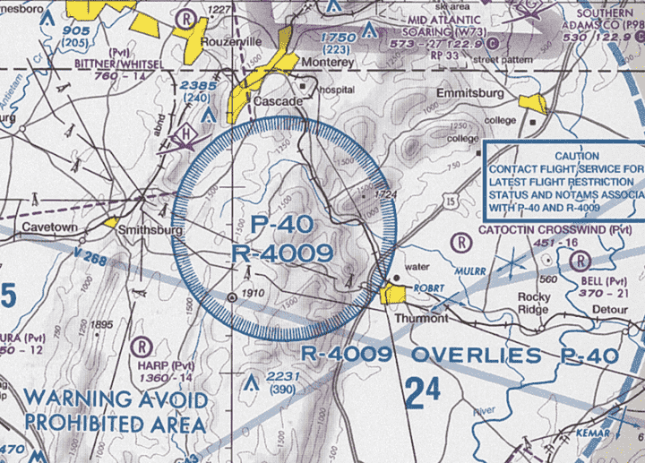
Prohibited Areas
These are areas that prohibit the flight of any non-authorized aircraft. These areas will usually be established for security purposes, or for other reasons that are related to national welfare. The designation of these areas can be found in the Federal Register, as well as on aeronautical charts.
Some examples of these prohibited areas include: Camp David, and the National Mall above the White House and Congressional buildings.
When looking at charts you’ll see these designated with a P along with a number. It is absolutely vital that you are aware of any prohibited areas along your flight path.
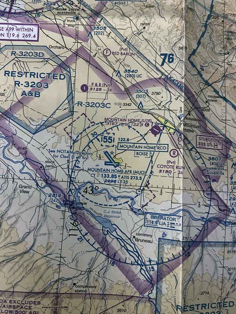
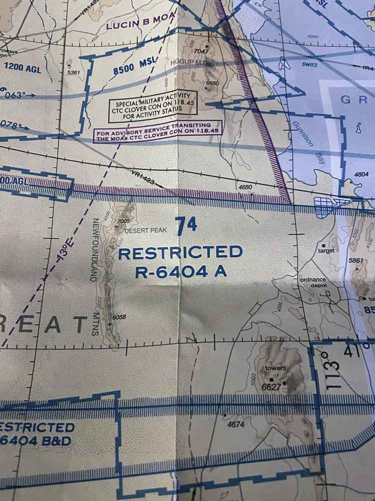
Restricted Areas
These are areas where operations may be hazardous to aircraft and are often related to military activities. However, restricted areas are different from Military Operations Areas. Flying in these areas is possible but requires approval and there may be restrictions on the activities an aircraft can engage in when flying in restricted areas.
The hazards in these areas can include artillery firing, aerial gunnery, and other military training that doesn’t necessarily include military pilot training.
Entering these areas without first gaining authorization from controlling agencies can be highly hazardous. ATC facilities apply these procedures when aircraft are not on IFR clearance:
· If area is non-active and has been released to the FAA, then the aircraft may operate in the space as normal without clearance.
· If the area is restricted and has not been released. The ATC facility issues or denies clearance to the aircraft into the airspace.
The letter R is used to chart restricted areas along with a number – such as R-4401. These can be seen on the en route chart for use at the altitude.
Curious about pilot pay? Learn how much you could earn at the airlines with our guide to pilot salaries.
Military Operation Areas
Also referred to as MOAs, military operation areas are airspaces that exist for the purpose of training military pilots. MOAs have defined vertical and lateral airspace that separates military training traffic from IFR traffic.
Where an MOA is actively being used, the nonparticipating IFR traffic will require clearance via the MOA. However, this will only be an option if the IFR separation can be offered by ATC. Otherwise, the IFR traffic will be redirected.
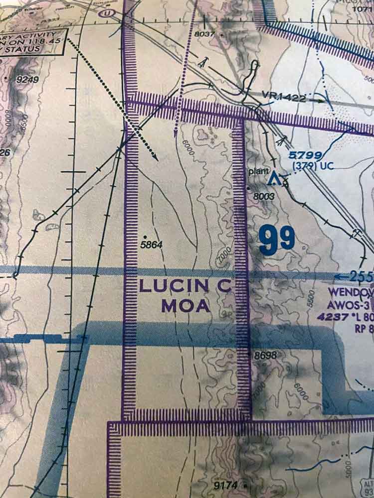
Be sure to review the sectional chart for the altitudes affected, the times of operation, and the controlling agency.
Controlled Firing Areas
CFAs are areas that contain potentially hazardous activities, however, you will not find these listed on any charts.
Instead these are activities that must be stopped as soon as a non participatory aircraft is spotted on radar, or from a ground or aerial lookout.
Non participatory aircraft do not have to change their flight path.
Warning Areas
Warning areas operate in a similar manner to restricted areas. The key difference is the US does not have sole jurisdiction. These areas are located from 3NM outward off the coast of the US. The activity here has been identified as being hazardous to nonparticipating aircraft, and the purpose of the jurisdiction is to warn pilots of potential dangers.
Warning areas could be located over international or domestic waters.
You’ll see these areas on a map designated with a W.
Alert Areas
Areas with a high volume of flight training or other unusual aerial activity are called alert areas.
Nonparticipatory planes are allowed to move through the space, however, they need to be alert and aware that training activities may be going on here. Both parties, those transiting the alert area, and those participating in the alert area are equally responsible for collision avoidance.
Alert areas can be identified on aeronautical charts by the letter A, followed by a string of numbers.
Other Airspace Areas
There are a huge number of additional airspace areas that refer to classifications not covered by the airspace classes we have addressed so far.
These include:
- Local airport advisory (LAA)
- Published VFR routes
- Parachute jump aircraft operations
- Temporary flight restrictions (TFR)
- Military training route (MTR)
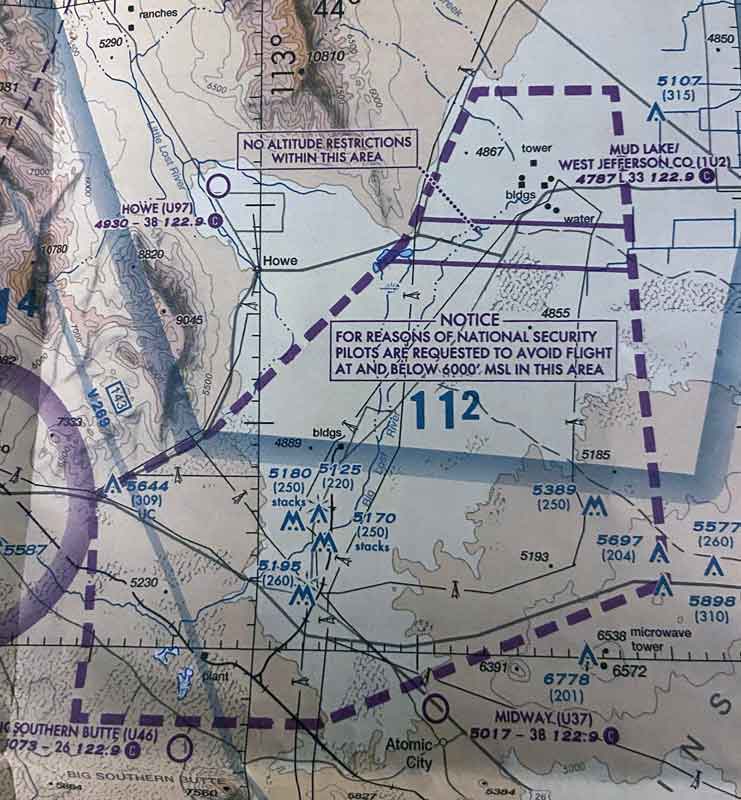
- National security areas (NSA)
- Air defense identification zones (ADIZ)
- Terminal radar service area (TRSA)
- Special awareness training
- Wildlife Areas/Wilderness Areas/National Parks: Request to operate above 2,000 AGL
- National oceanic and atmospheric administration marine areas off the coast with a requirement to fly above 2,000 AGL.
- Tethered Balloons for observation and weather recordings that extend on cables up to 60,000 ft
Each of these operates in a slightly different way. In many cases, the title is descriptive of the nature of the airspace.
For example, a military training routes are routes that are used by military aircraft to practice proficiency in tactical flying. These will usually be located below 10,000 feet MSL, at speeds above 250 knots.
Parachute jump aircraft operations meanwhile are areas used for precisely that, which may require special care and attention when passing through.
Wildlife areas might include a request to fly at above 2,000 AGL. This will ensure that birds and other wildlife will not be frightened or endangered by aircraft.
One other particularly important one to know is temporary flight restrictions. These are issued by a flight data center and come out as a notice to airmen. They include the location of the temporary restriction, the defined statute miles, the altitude, and the times of the restriction. You’ll often see these appear when the President or Vice President comes to visit a city.
There are many more types of airspace and it is important to understand the difference between each type. Pilots should be familiar with the operational requirements for each class, and that includes those that are less common.
To learn more about airspace classes you can visit the FAA’s website with greater detail on each type of airspace.